Scope of Work
PREPARATION OF CONCEPTUAL MASTER PLAN TO MITIGATE FLOODS IN NORTH GUJARAT
North Gujarat experienced severe flooding in 2015 and 2017. Further to this, the work of preparing conceptual master plan to mitigate floods in North Gujarat is entrusted to SECON Pvt. Ltd in 2017.
- Preparing a Detailed Project Report including the conceptual master plan to reduce the effect of flooding of the selected flood inundated areas in the five districts of Gujarat namely Mehsana, Banaskantha, Ahmedabad, Patan and Surendranagar over an area of 5,500 sq. km;
- Feasibility studies, Conceptual Master Plan and Detailed Project Report for flood reduction measures
- • To gain understanding of the reasons behind the recent flood events at various selected study areas, proposing the best flood prevention measures;
- • Preparing hydrology and hydraulic modelling report, flood inundation maps, annual and regular maintenance plan for drains.
The scope of work includes:
DEVELOPING A REAL TIME FLOOD FORECASTING SYSTEM AND WEB-BASED DECISION SUPPORT SYSTEM FOR THE CHENNAI CITY AND ITS NEIGHBORHOOD
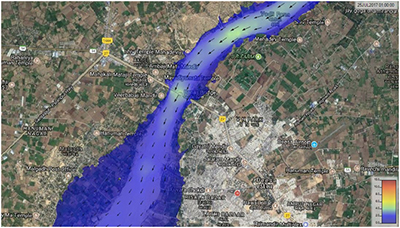
The Chennai city and its suburb experienced major flooding in 1943, 1976, 1985, 1996, 2002, 2005, and 2015 with 2015 event being the most severe of all (US$2.2 billion. Subsequently, SECON have been appointed to equip the State Emergency Operation Centre, Chennai, Greater Chennai Corporation and 10 surrounding Urban Local Bodies (ULB) by Planning, setting up and Operationalizing a Real Time Flood Forecasting and Spatial Decision Support System in the four basins namely Cooum (489.32 Sq.km), Adyar (1,162.46 Sq.km), Kosasthalayar (3,850 Sq.km) and Kovalam (472.75 Sq.km
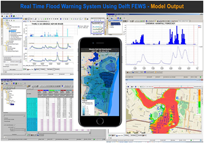
- Setting up the 1D/2D linked hydrodynamic model- Real time River flow/ Flood Forecasting Model, Lake and Water Bodies Operation Guidance System (LOS) and Spatial Decision Support System
- Review existing institutional arrangement
- Capacity Building; Handholding and Support
- Operation and Maintenance phase of real time flood forecasting system.
The scope of work includes: